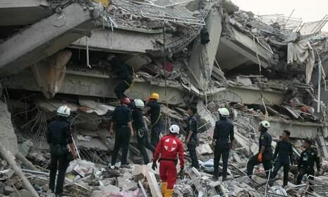
EARTHQUAKE DISASTER IN MYANMAR AND THAILAND
The Global Geoparks Network extends its deepest sympathy and solidarity to the people of Myanmar and Thailand, as well as to our colleagues in the UNESCO Global Geoparks across the region, following the devastating earthquake on Friday, March 28, 2025. This tragic event resulted in significant loss of life and caused severe damage to cities, villages, homes, public facilities, infrastructure, and heritage sites, particularly in rural communities in Myanmar and even in big cities in Thailand!
We are living in the dynamic Earth which always changing. The movement along plate boundaries will create sudden break on the Earth’s crust, creating major earthquake. What happen ini Mandalay Myanmar is the sudden break along Indian ang Asia plate, which produced M = 7.7 earthquake. This is the geological event turn to a very sad disaster. Therefore, understanding geological phenomena are crucial to reduce the risk to humanity due to natural disaster.
In recent years, global warming has contributed to the increasing frequency of natural hazards, including hurricanes, torrential rains, melting glaciers, and desertification due to extreme weather conditions. Geological hazards such as earthquakes, tsunamis, and volcanic eruptions continue to impact various parts of the world.
These natural disasters have affected many regions, including UNESCO Global Geoparks. Examples include earthquakes in Morocco, Japan, China, and now Myanmar, large-scale floods in Southeast Asia, Brazil, and Central Europe, as well as devastating forest fires in Korea, Portugal, Greece, California, Australia, and Brazil. Additionally, landslides, droughts, heatwaves, and water shortages have become more frequent. Furthermore, many of these hazards are interconnected, leading to compound or cascading disasters.
Geoparks serve as spaces to appreciate, protect, and utilize the geomorphological and geological heritage that provides valuable insights into Earth's history. Understanding the dynamic relationship between humans, nature, and the environment is crucial in preparing for and mitigating the impacts of natural disasters. It is essential to study both geophysical and climate-induced hazards to enhance disaster preparedness.
The Myanmar earthquake serves as a reminder that natural disasters occur regardless of political circumstances or levels of preparedness. This event took place along a distinct active fault line influenced by the same plate movements that formed the Himalayas. It underscores the fact that Earth's dynamic processes continue to shape not only China but also other countries in the Indochinese Peninsula.
Beyond understanding the scientific background of such disasters, the ability of communities to respond and recover depends significantly on their level of preparedness. UNESCO Global Geoparks play a crucial role in disaster risk reduction by fostering awareness, education, and proactive measures. These efforts may include studying past and potential future disasters, incorporating disaster risk into urban planning, collaborating with governments and communities, conducting evacuation drills, and developing hazard maps. However, effective disaster risk reduction requires the active participation of all community members.
UNESCO Global Geoparks can contribute to disaster resilience by disseminating geoscientific knowledge, encouraging discussions on sustainable regional development, and promoting strategies for reducing disaster risks. By fostering awareness and preparedness, we can help ensure safer and more resilient communities in the face of future geohazards.